27 Feb State Says 12 Contra Costa Cities Have Very High Fire Hazard Severity Areas
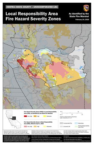
Fire hazard severity zones are shown in Contra Costa County in this map released by Cal Fire on Tuesday. Cal Fire released maps for all California counties. (Cal Fire via Bay City News)
By Tony Hicks
Bay City News
Areas of Orinda, Richmond, Moraga, San Pablo, Lafayette, Antioch, Clayton, El Cerrito, Brentwood, Danville, Concord, and Pinole are considered very high fire hazard severity zones, according to new maps released this week by the Office of the State Fire Marshal.
All of those cities also have unincorporated areas near them listed in the highest category of severe fire danger.
The state said fire hazard zones in California have grown due to climate-driven droughts and longer, more dangerous wildfire seasons.
After the disastrous Southern California firestorms earlier this year, Gov. Gavin Newsom ordered the state to update its statewide Fire Hazard Severity Zone maps for the first time since 2011.
“We are living in a new reality of extremes,” Newsom said in a Feb. 6 statement. “Believe the science — and your own damn eyes. Mother Nature is changing the way we live and we must continue adapting to those changes. California’s resilience means we will keep updating our standards in the most fire-prone areas.”
Newsom’s order directed the State Board of Forestry to adopt regulations known as “Zone 0,” requiring an ember-resistant zone within 5 feet of structures located in the highest fire severity zones in the state.
Along with updating fire severity maps, the order adds 1.4 million new acres of state land into the two higher tiers of fire severity, which will update building and local planning requirements in affected communities.
The state is releasing the maps in phases. Maps including the Bay Area were released Tuesday.
The zones can be found at https://bit.ly/3QDAHnk.
According to the state fire marshal’s website, the maps use a science-based and field-tested model assigning a hazard score based on factors influencing fire likelihood and fire behavior.
Fire history, existing and potential fuel (natural vegetation), predicted flame length, blowing embers, terrain, and typical fire weather.
There are three levels of hazard assigned to areas of possible fires: moderate, high, and very high. State law requires homeowners to clear at least 100 feet of defensible space around homes in very high hazard zones, unless local ordinances require more.
The Contra Costa County city with the most acreage in the “very high” category of severe fire danger is Orinda, with 5,241 acres, not including nearby unincorporated areas. That’s more than twice the acreage in 2011, when the state said Orinda had 2,424 acres considered a very high hazard.
Orinda also has 803 acres in the “high” category and 928 “moderate” acres.
The fire marshal’s office said the maps evaluate “hazard,” not “risk.”
“They are like flood zone maps, where lands are described in terms of the probability level of a particular area being inundated by floodwaters, and not specifically prescriptive of impacts,” the office said on its website. “‘Hazard’ is based on the physical conditions that create a likelihood and expected fire behavior over a 30-to-50-year period without considering mitigation measures such as home hardening, recent wildfire, or fuel reduction efforts.”
Contra Costa’s second largest “very high” hazardous area is in Richmond with 4,395 acres, up from 4,129 in 2011.
Both Orinda and Richmond’s highest risk of wildfires are in steep hillside areas.
Not surprisingly, Orinda’s neighbor Moraga — which borders the Las Trampas Wilderness Regional Preserve — has the third most hazardous acreage with 2,290 acres, up from only 419 acres in 2011.
Moraga has 2,238 acres considered “high” and 863 “moderate” acres.
The state said Clayton has 1,302 very high hazardous acres, another 359 considered high and 215 considered moderate.
Lafayette had more acres in the very high category than any other city in Contra Costa in 2011. By 2025, that number moved down to 41, though Lafayette now has 5,309 acres considered high hazard — more than any city in Contra Costa.
People can see what zone they’re in by going to osfm.fire.ca.gov/FHSZ.
Copyright © 2025 Bay City News, Inc. All rights reserved. Republication, rebroadcast or redistribution without the express written consent of Bay City News, Inc. is prohibited. Bay City News is a 24/7 news service covering the greater Bay Area.
No Comments